Objectives
The goal of this assignment was to become familiar with the process of downloading data from different sources on the internet then organizing and preparing the data for use in ArcGIS. This included joining some data, projecting all data from different sources into a common coordinate system and building a geodatabase in which to store and organize the newly prepared data. Since focus is given to Trempealeau County, a Python script was written to clip all data to the border of this county which you can read more about here.
The data collected from this exercise will be used for later activities this semester in exploring issues surrounding sand mining and creating a suitability and risk model for sand mining in Tremplealeau County.
Methods
Data on sand frac mining in Trempealeau County, Wisconsin was collected by first downloading zip files and extracting them to a working folder. Then, using Python Scripting, the data was projected into a common coordinate system, clipped to the Trempealeau County border, and extracted. A geodatabase was built and the projected and clipped data was then loaded into it and extra, redundant data was deleted to better organize the data. This can be summarized by the data flow model taken from our exercise instructions sheet below (Fig. 1). The final step was to create metadata for the downloaded data to assess data accuracy.
 |
| Figure 1: Data flow model depicting the process of downloading data from different sources and preparing them for use in ArcGIS. |
Step One: Downloading Data From Various Internet Sources
Data was first gathered from different internet sources by navigating source sites and downloading zip files of the data of interest. The data zip files and the sources from which they were obtained are listed below:
1. USDT NTAD Railway Network at http://www.rita.dot.gov/bts/sites/rita.dot.gov.bts/files/publications/national_transportation_atlas_database/2015/polyline
2. USGS Elevation Data at http://nationalmap.gov/about.html
3. USDA National Land Use Data at http://datagateway.nrcs.usda.gov/
4. Trempealeau County land records Trempealeau County Geodatabase at http://www.tremplocounty.com/landrecords/
5. USDA NRCS Web Soil Survey SSURGO data at http://websoilsurvey.sc.egov.usda.gov/App/HomePage.htm
Once the data were downloaded as zip files into a temporary folder, I extracted the data from the zip files into a working file. I then separated raster data in .tif form for the elevation data, railroads, soils, land use, and croplands into a newly created geodatabase to be processed.
Step Two: Using Python Scripting to Process the Data and Load into a New Geodatabase
I created a python script in Python Script Editor (found here) to project the raster files into the same coordinate system as the data in the Trempealeau County Geodatabase and clip the data by the county boundary and save the new data in the newly created geodatabase (Fig.2). After this was completed, I then created maps depicting the elevation data, croplands, and land use (seen in the results section) (Fig. 3-5).
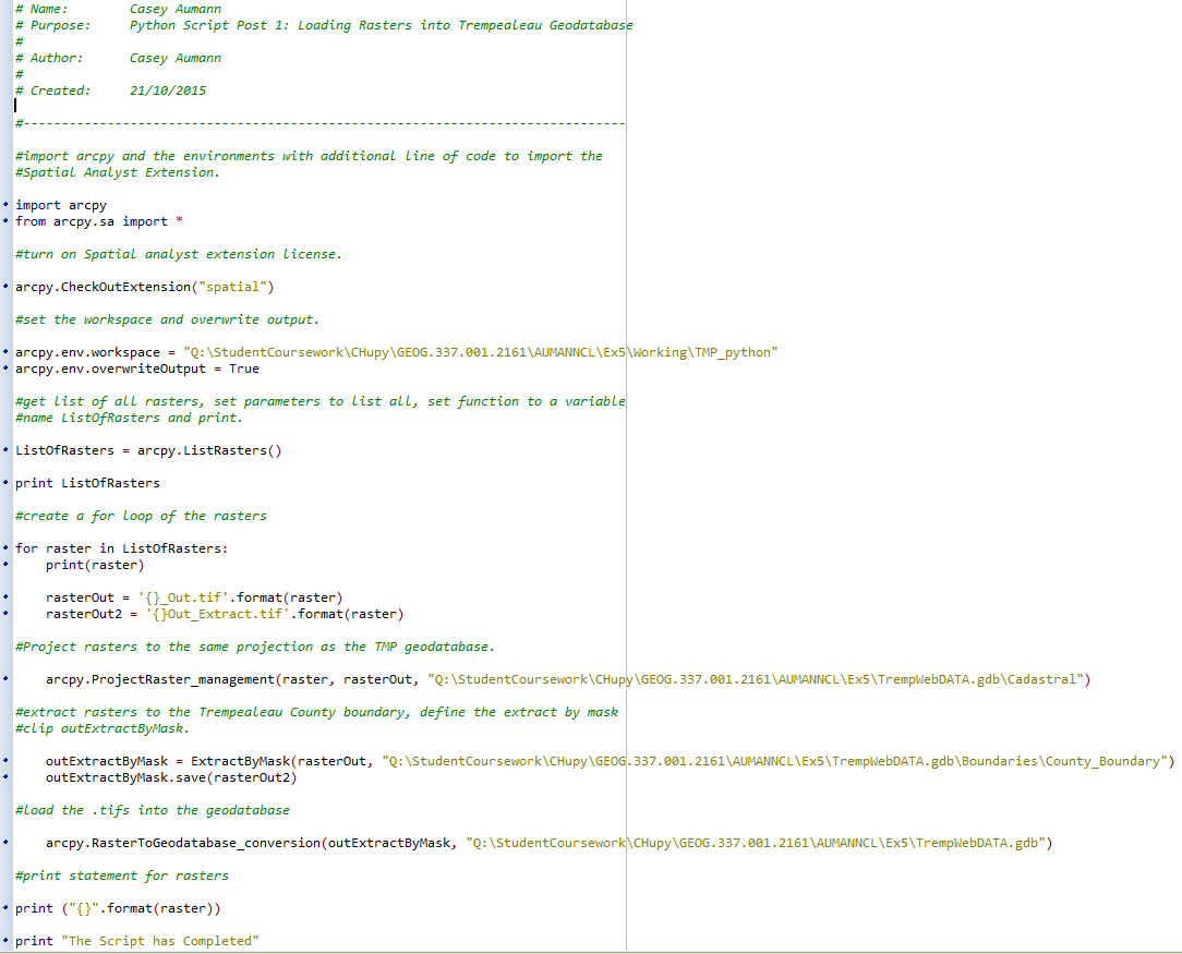 |
| Figure 2: Python Script used for processing. |
Step Three: Deleting Redundant Data
After all data was downloaded, organized, extracted, processed, and saved into a single geodatabase, it was important to delete redundant data to free space in the computer storage and ensure proper organization. For this reason, I created a metadata table for the data downloaded. The table includes scale, effective resolution, minimum mapping unit, planimetric coordinate accuracy, lineage, and temporal and attribute accuracy. The finished table can be seen in the results section (Fig.6).
Step Four: Creating Metadata for Data Accuracy
Because the data in this exercise was collected from multiple sources and will be used later to investigate issues surrounding sand frac mining in western Wisconsin, it is important to keep a record of metadata of all data to ensure accuracy of future analysis.
Results
The figures below show the maps of Trempealeau County elevation, croplands, and land use after downloading, projecting, clipping data from various sources (Fig. 3-5). The finished metadata can also be seen below (Fig. 6).
Maps
Maps


Figure 3-5: 3) (left) Digital elevation model of Trempealeau County from USGS, 4) (middle) Croplands/Agriculture in Trempealeau County from USDA, 5) (right) Land Use in Trempealeau County from USDA/NASS.
Metadata
 |
| Figure 6: Metadata of downloaded data. "NA" indicates the areas I was unable to find. |
Conclusion
Successfully downloading, organizing, and processing data as well as locating and understanding metadata and data accuracy is a critical part of any project using geospatial information systems. In this lab, we gained exposure to these processes, using python scripting to complete the processing portion of this activity which included projecting and clipping to the Trempealeau County border. This lab's data collection, processing and metadata and data accuracy results are valuable for future analysis that will take place in this semester's project in assessing suitability and risk of frac sand mining in Trempealeau County.
No comments:
Post a Comment