Wednesday, October 21, 2015

Data Gathering

Objectives


The goal of this assignment was to become familiar with the process of downloading data from different sources on the internet then organizing and preparing the data for use in ArcGIS. This included joining some data, projecting all data from different sources into a common coordinate system and building a geodatabase in which to store and organize the newly prepared data. Since focus is given to Trempealeau County, a Python script was written to clip all data to the border of this county which you can read more about here.

The data collected from this exercise will be used for later activities this semester in exploring issues surrounding sand mining and creating a suitability and risk model for sand mining in Tremplealeau County.

Methods


Data on sand frac mining in Trempealeau County, Wisconsin was collected by first downloading zip files and extracting them to a working folder. Then, using Python Scripting, the data was projected into a common coordinate system, clipped to the Trempealeau County border, and extracted. A geodatabase was built and the projected and clipped data was then loaded into it and extra, redundant data was deleted to better organize the data. This can be summarized by the data flow model taken from our exercise instructions sheet below (Fig. 1). The final step was to create metadata for the downloaded data to assess data accuracy.

Figure 1: Data flow model depicting the process of downloading data from different sources and preparing them for use in ArcGIS.


Step One: Downloading Data From Various Internet Sources

Data was first gathered from different internet sources by navigating source sites and downloading zip files of the data of interest. The data zip files and the sources from which they were obtained are listed below:

1. USDT NTAD Railway Network at http://www.rita.dot.gov/bts/sites/rita.dot.gov.bts/files/publications/national_transportation_atlas_database/2015/polyline

2. USGS Elevation Data at http://nationalmap.gov/about.html

3. USDA National Land Use Data at http://datagateway.nrcs.usda.gov/

4. Trempealeau County land records Trempealeau County Geodatabase at http://www.tremplocounty.com/landrecords/

5. USDA NRCS Web Soil Survey SSURGO data at http://websoilsurvey.sc.egov.usda.gov/App/HomePage.htm


Once the data were downloaded as zip files into a temporary folder, I extracted the data from the zip files into a working file. I then separated raster data in .tif form for the elevation data, railroads, soils, land use, and croplands into a newly created geodatabase to be processed.


Step Two: Using Python Scripting to Process the Data and Load into a New Geodatabase 

I created a python script in Python Script Editor (found here) to project the raster files into the same coordinate system as the data in the Trempealeau County Geodatabase and clip the data by the county boundary and save the new data in the newly created geodatabase (Fig.2). After this was completed, I then created maps depicting the elevation data, croplands, and land use (seen in the results section) (Fig. 3-5).

Figure 2: Python Script used for processing.

Step Three: Deleting Redundant Data

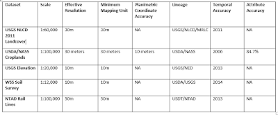
After all data was downloaded, organized, extracted, processed, and saved into a single geodatabase, it was important to delete redundant data to free space in the computer storage and ensure proper organization. For this reason, I created a metadata table for the data downloaded. The table includes scale, effective resolution, minimum mapping unit, planimetric coordinate accuracy, lineage, and temporal and attribute accuracy. The finished table can be seen in the results section (Fig.6).


Step Four: Creating Metadata for Data Accuracy

Because the data in this exercise was collected from multiple sources and will be used later to investigate issues surrounding sand frac mining in western Wisconsin, it is important to keep a record of metadata of all data to ensure accuracy of future analysis.


Results

The figures below show the maps of Trempealeau County elevation, croplands, and land use after downloading, projecting, clipping data from various sources (Fig. 3-5). The finished metadata can also be seen below (Fig. 6).

Maps


Figure 3-5: 3) (left) Digital elevation model of Trempealeau County from USGS, 4) (middle) Croplands/Agriculture in Trempealeau County from USDA, 5) (right) Land Use in Trempealeau County from USDA/NASS.


Metadata

Figure 6: Metadata of downloaded data. "NA" indicates the areas I was unable to find.

Conclusion

Successfully downloading, organizing, and processing data as well as locating and understanding metadata and data accuracy is a critical part of any project using geospatial information systems. In this lab, we gained exposure to these processes, using python scripting to complete the processing portion of this activity which included projecting and clipping to the Trempealeau County border. This lab's data collection, processing and metadata and data accuracy results are valuable for future analysis that will take place in this semester's project in assessing suitability and risk of frac sand mining in Trempealeau County. 


Sand Mining In Western Wisconsin Overview

Overview of the Project:

Throughout this semester, I will be gathering information on and creating a series of maps showing topics about frac sand mining in Western Wisconsin. This first post is an introduction to what frac sand mining is, where it takes place in Wisconsin, and the issues surrounding it.

Frac sand and sand frac mining: What is it and where is it?

Frac sand is a particular type of sand that has a quartz sand with high silica content and uniform size and spherical shape (Fig. 1) It is also resistant to large compressive forces--up to several tons per square inch, making it perfect for hydraulic fracturing processes, or "fracing" for short (1). This is where it gets its name.

Figure 1: Frac sand (right) and regular sand (left). Note the uniformity in size and shape in the frac sand. The white coloration is also an indication of its quartz content (1).

Wisconsin has an abundant source of frac sand found in sandstone deposits from the Cambrian and Ordovician periods in the western and central regions of the state (Fig. 2)(5). It has been mined for more than 100 years for a variety of purposes such as glass manufacturing and even golf course traps (2). However, recent development of sand frac mining (hydraulic fracturing) as a method of obtaining oil and natural gases has increased the demand for frac sand significantly since its appearance in the late 1990s (4). In fact, in the entire United States, Wisconsin now holds 75% of the market for frac sand according to an article by the Wisconsin League of Conservation Voters (3).
Figure 2: Frac sand deposits (sandstone) and frac sand mines and processing plant locations in Wisconsin updated in October, 2013. (5).


Figure 3: Sand frac mining well. A well is drilled
vertically to the rock layer containing oil and natural gas 
(in this image it is preresented as the Marcellus Shale), 
and then drilled horizontally through the rock layer. 
Fissures erupt in the Hydrofrac Zone as a result of 
high pressure treated water and kept open by frac sand (2).
Sand frac mining is used to free oil deposits trapped thousands of feet below the ground. It is done by drilling a well vertically down to the rock layer where the oil is present, then the well is drilled horizontally along this rock layer (Fig. 3). Water treated with chemicals and mixed with frac sand is forced through the well into the rock layer at incredible pressure until the surrounding rock layer has reached its breaking point and creates fissures in what is known as the "hydrofrac zone" (2). After the pumps forcing water into the rock are turned off, the fissures deflate somewhat but are kept open by the frac sand, allowing the oil and natural gases trapped in the rock layer are then free to flow through the well.


What are the issues?


One issue facing frac sand mines is sediment dispersal. Mining sand sets free many dust particles into our air containing crystalline silica, a cancer-causing agent (discussed in the video below). Other respiratory issues that can be caused by the silica dust includes silicosis, an irreversible lung disease, and asthma. In June, 2012, the federal government even released a occupational hazard alert after research showed locations near some mines contained as much as 10% more than the recommended silica dust content in the air. (7). Not only does the dust cause respiratory issues, but it can pollute nearby streams and cover roads. In one case, a sediment plume left a 6-inch-deep layer of dust on a nearby road in Trempealeau County (6). Some citizens are also worried about the general effect on the landscape as sand mines are rapidly transforming the natural landscape of Western Wisconsin.


Other issues such as increased rail road usage sparks complains about noise, frequency of traffic increases on roads, and safety associated with the transportation of flammable crude oils across Wisconsin and the questionable ability of old rails to support the movement of heavier loads (8).


How can GIS be used to explore these issues?

GIS can help to understand the issues surrounding frac sand mining in Western Wisconsin. For instanc, it can help to find optimum areas of frac sand mines away from larger towns and residential areas to avoid air pollution for local residents. It can also explore the railroad and vehicular transportation to find what routes are best for transporting sand and the proximity of lakes, rivers and streams to sand mines to lessen the traffic and pollution effects of transporting and mining sand. For this semester's project, I will be using GIS to explore issues in Trempealeau County, Wisconsin by using data on crop land, land use, railroads, and digital elevation models from the USGS, USDA, and Trempealeau County geodatabases.


References:

(1)King, H. (n.d.). "What is Frac Sand?" Geology.com, Geology News and Information. Retrieved 23 Oct. 2015 from http://geology.com/articles/frac-sand/

(2)Mining: Frac Sand. (n.d.) Wisconsin Geological Natural History Survey. Wisconsin Board of Regents of the University of Wisconsin System, 2013. Retrieved 23 Oct. 2015 from https://wgnhs.uwex.edu/wisconsin-geology/frac-sand-mining/

(3) "Frac Sand Mining," Wisconsin League of Conservation Voters. Mo' Better Communications. Retrieved 23 Oct. 2015 from http://conservationvoters.org/issues/frac-sand-mining/

(4) Lallanilla. "Facts About Fracking," LiveScience. TechMedia Network, 23 Jan. 2015. Retrieved 23 Oct. 2015 from http://www.livescience.com/34464-what-is-fracking.html

(5) "Frac Sand IN Wisconsin Fact Sheet." Wisconsin Geological and Natural History Survey. Retrieved 23 Oct. 2015 from http://wcwrpc.org/frac-sand-factsheet.pdf

(6) "Frac Sand Mining Company Faces $200,000 in Water, Air Penalties." WisconsinWatchorg. 17 Dec. 2013. Retrieved on 23 Oct. 2015 from http://wisconsinwatch.org/2013/12/frac-sand-mining-company-faces-200000-in-water-air-penalties/

(7) Peeples, Lynne. "Does Frac Sand Mining Rush In Wisconsin Threaten Public Health?" The Huffington Post. TheHuffingtonPost.com. Retrieved on 23 Oct. 2015 from http://www.huffingtonpost.com/2012/12/07/frac-sand-mining-wisconsin-health_n_2256753.html 

(8) "As Rail Moves Frac Sand across Wisconsin Landscape, New Conflicts Emerge." WisconsinWatchorg. 13 July 2014. Retrieved on 23 Oct. 2015 from
 http://wisconsinwatch.org/2014/07/as-rail-moves-frac-sand-across-wisconsin-landscape-new-conflicts-emerge/